social_trails_plan_gary_giacomini_preserve
TRAIL CLOSURES: Marin County Parks and Open Space is seeking to decommission 6,000 feet of social trails in the Gary Giacomini Preserve. It’s also seeking to incorporate 5,000 feet of those trails.   David Briggs

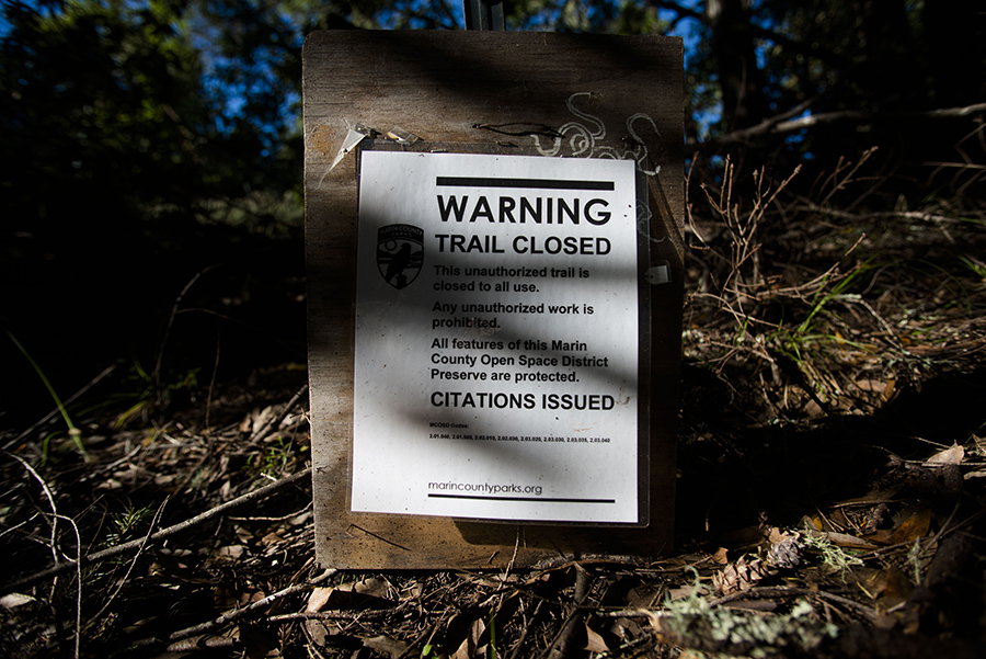
The Marin County Open Space District is planning to integrate 5,000 feet of social trails known as the Hunt Camp Trail into its official network in the Gary Giacomini Preserve while upgrading those paths to reduce their environmental impact. 

But the project, which is open for public comment until May 15, will also include decommissioning 6,000 feet of social trails that the county has deemed erosive, redundant or too steep. 

The prospect of some of those closures—as well as the recent closure of a handful of other social trails in the San Geronimo Valley—has one resident frustrated. 

Albert Flynn DeSilver, a poet who lives in Woodacre, says the county’s effort to reduce the amount of trail in the area is affecting trails that have existed for many years and that provide alternative, and sometimes quieter, routes while dispersing trail traffic.

The Hunt Camp project is one of seven projects the Open Space District is tackling this year. Since the approval of the Road and Trail Management Plan in 2014, the agency annually announces projects it will undertake. Many projects come from feedback given during community meetings. (The valley had its in 2015.) The public can also propose trail projects.

Last year, for instance, the county adopted and improved about 14,000 feet of social trails while decommissioning another 4,000 feet in the Gary Giacomini Preserve. That project spurred a lawsuit filed last year by the Marin Audubon Society due to concern over impacts of construction work on the northern spotted owl.

The Hunt Camp Trail has existed for about 60 years, according to John Campo, a senior natural resources planner for the Open Space District. The trail is named—no surprise—for a hunting camp that once existed at the top of the trail. “It has a lot of history in the community,” he said.

According to a county report on the project, the Hunt Camp Trail is a narrow, two to three-foot wide trail that connects San Geronimo Ridge to the bottom of the valley. The proposed work includes reducing erosion problems; improving sightlines; rerouting two small sections away from steep grades and sensitive habitat, including the rare Marin Manzanita; and improving creek crossings by building a pair of 20-foot bridges as well as installing rock in seven other areas to stop sediment from entering the creek. 

Additionally, four separate lengths of trail will be decommissioned. That work can include combing over the soil, obstructing the path with boulders or saplings and installing native plants.

Most of the trail will be open to hikers and bikers, but one section connecting the trail to Juniper Avenue will be for hikers exclusively, according to the current proposal. The project may also include a new 2,100-foot-long connector trail from the lower portion of the Hunt Camp Trail to the Manzanita Fire Road.

Mr. Campo said the county has so far received about 50 comments on the plans; he said most were positive, with just a couple critical responses. Max Korten, head of Parks and Open Space, said the comments would be made public after the closure of the comment period.

Tom Boss, the off-road and events coordinator for the Marin County Bicycle Coalition who lives in Forest Knolls, said he and his group support the Hunt Camp project. He estimated that adopting the trail into the official system will add about 1.5 miles of biking opportunity. “It makes modifications to help the environment, which we fully support,” he said.

He also called the decommissioning a trade-off. But, he added, “From our point of view, we did a lot of outreach and we know what the community wants… The [trails] identified for decommissioning were not seen as important for hikers and bikers.”

Jean Berensmeier, a longtime valley resident and former Open Space commissioner, has reservations about allowing bike traffic on the Hunt Camp Trail. She described it as steep and narrow, and believes those factors will lead to exclusive bike use.

“And that is not fair or right. We already have three families in the San Geronimo area that have quit hiking their favorite narrow trails because of their fear of encountering speeding downhill bikers,” she wrote in an email. 

Mr. Campo said improved sightlines, and the rerouting of the trail from its steepest section, are meant to reduce the potential for user conflict.

But Mr. DeSilver is a fierce advocate for social trails, believing they play an important role in diffusing trail traffic. He also stressed the need for alternate routes for hikers.

“Hikers want to have a quieter, remote experience,” he said.

For example, the longest section of road slated for decommissioning in the Hunt Camp project connects Conifer Fire Road to the Willis Evans Trail. The county argues that the unnamed 3,590-foot path is redundant because it runs roughly parallel to the Conifer Fire Road. 

Mr. DeSilver, who said the trail is known by locals as the Woody Trail, disagrees; for him, the idea that a trail would be redundant misses the point that it offers a unique experience, with different sights and sounds.

He recognizes that some social trails do suffer from problems like erosion. Woody Trail, he said, has areas that are steep and rutted and one section abuts private land. He agrees that it should probably no longer be used as is, but that it should be rerouted, not decommissioned.

This Monday morning, Mr. DeSilver walked down a recently closed social trail he called West Evans Canyon, in the Gary Giacomini Preserve. It switchbacks up a canyon, and piles of brush and thin trees county workers used to close the trail—which he worries are a fire hazard—lay on the side of the path. A creek murmured nearby before he reached a hillside of wildflowers. It is a trail he loves. 

It is also a trail he will not stop using, despite the fact that he said he’s paid $1,600 in citations, the result of a camera that captured his image walking on closed trails. “They’ve demonized it as an illegal trail,” he said. “I don’t believe there is such a thing as an illegal trail.”

A Woodacre resident who lives nearby, Steve Evans—whose father is the namesake of the Willis Evans Trail in the preserve—said he often used the path. “I thought it was an awesome trail,” he said, the best way to traverse the steep canyon.

The county, on the other hand, is geared to both providing access and reducing environmental harm. “We’re trying to defragment the land and restore the land and leave room for wildlife,” Mr. Campo said.

Mr. Korten said the goal is to create a sustainable system of trails—that is, a system that has fewer environmental impacts and is possible for staff to manage. He also noted that people have mostly abided by the closures. “By and large, the public has been really, really great,” he said. “There are literally a couple of people that we have issued citations to, who went into restoration sites.”

Yet adding to his complaints, Mr. DeSilver says the trail he walked Monday was not included in a 2011 county-commissioned survey of social trails, the first step in the process to decide which trails to close and which to include in its system. As a result, people would not have known to comment on it during the public process.

The county has said that any trails it believes were built after 2011 can be decommissioned at its discretion. On the other hand, social trails that it recognizes have existed for a while, such as those to be decommissioned through the Hunt Camp project, go through a public process.

Mr. DeSilver stressed that the trail indeed existed before 2011, and he wonders if it was left out purposefully so it could be closed more easily.

For his part, Mr. Campo insists it was created after 2011, adding that he consulted with some people in the community about just that question.

In a way, both may have a claim to the truth. Mr. Evans, who said he is sympathetic to the district’s need to manage its system, said he has walked a light path there for decades. “But it was illegally improved by some vigilante… Someone said, ‘Let’s make a cool trail.’ As soon as Open Space realized someone was trying to make a trail, they closed the whole thing down.”


To read about the Hunt Camp Trail project, visit goo.gl/lv0Ts9. To comment, email [email protected].