
Seventeen years after the Point Reyes National Seashore proposed that three Bolinas row croppers change the way they use Pine Gulch Creek, a project that will bank over 21 million gallons of winter water finally broke ground this month.
When construction is complete this fall, five storage ponds will provide water drawn during the rainy season to three farms—Warren Weber’s Star Route Farm, Peter Martinelli’s Fresh Run Farm and Dennis Dierks’s Paradise Valley Produce—during summer. In return, the farms will cease drawing creek water in the dry season, when flows are at their lowest.
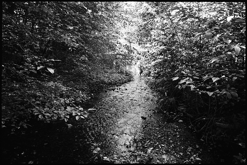
Most of the main stem of Pine Gulch, which is about seven miles long, runs through federal park land. But the final two miles flow through private land, and all the water diversions are located in this final stretch before the creek empties into the Bolinas Lagoon.
The project, which the Marin Resource Conservation District has spearheaded since 2007, is intended to simultaneously protect the creek and help the farmers continue cultivating their crops; it has been heralded as a win-win for both the environment and agriculture. But it has taken years to secure numerous approvals. A final permit, from the Army Corps of Engineers, took five years and came just in the nick of time: a $2.4 million grant to build the ponds, from the California Department of Fish and Wildlife, would have been rescinded if the project hadn’t commenced this summer.
Though at least one stipulation in the project—about how much water needs to be flowing for water to be drawn during the winter—poses a significant challenge to farmers, yet they are still overwhelmingly supportive.
“The whole idea of off-stream storage for row crops, or any crops, is a great model for California,” Mr. Martinelli said. “We have flashy winters with lots of rain at one time… This is a great way to harvest water when there’s an abundance, and not go after the stream flow in the dry season.”
Pine Gulch has been used to foster agriculture for many decades. Mr. Martinelli’s family used the creek to irrigate the land for grazing starting in the 1940s. Since the 1960s, the creek has been used largely for vegetables.
The farmers depend on a certain level of stream flow for their pumps to work effectively; at the same time, they strive to be stewards of the watershed. During the summer, the farms have coordinated their draws so they do not pull water simultaneously when flows are particularly meager.
Still, the National Park Service has determined that the diversions affect the stream. A 2013 report by the National Marine Fisheries Service’s office in Santa Rosa said that during summers between 1998 and 2005, “NPS reported unnatural variation in stream flow below the diversion sites.” (The park service installed a flow gauge in the creek in 1998.)
Two other agricultural operations use the creek: Gospel Flat Farm and Las Baulines Nursery. But Gospel Flat, which abuts Bolinas Lagoon, uses much less water because its acreage is already so saturated, and Las Baulines cultivates less than an acre.
In 1998, the seashore proposed that the three largest farmers temporarily store creek water in off-stream ponds. The point of the project was, and still is, to conserve stream flows during the summer, when they are lowest and fish are most vulnerable. Ceasing irrigation in the summer will boost creek flows and create better pools and riffles, critical habitat for growing fish, according to the fisheries service’s white paper.
At the time the proposal was made, there were some steelhead in the creek, but coho had not been spotted in many decades.
“The stream is a very important part of all of our farms,” Mr. Dierks, of Paradise Valley, said. “So this seemed like a good opportunity to address the fish and do what we could do as farmers to impact the system.”
The original plan conceived of much smaller ponds that would act as a cushion, but not a complete water allotment, during the dry season.
The farmers, the seashore, the C.D.F.W. and the fisheries service worked for years on the project, which was all but set to go when twin occurrences put on the brakes: the seashore spotted a coho in Pine Gulch in 2001, and a year later, California listed coho as endangered.
“Suddenly there was a lot more at stake in terms of taking species. They had to redesign the ponds around these new regulations,” said Nancy Scolari, the executive director of the conservation district.
The project, Mr. Martinelli said, had to be conceived on a much grander scale because C.D.F.W. no longer wanted the farmers to take any water during the dry season. Although no one directly told the farmers they might someday be barred from drawing water in the summer, he said that “in a regulatory sense, that’s where we were headed. Either mitigate your take or stop farming.”
The latter was not an option that Mr. Martinelli—who sang the praises of the rich, loamy soil in the rift zone of the San Andreas—wanted to imagine.
The crux of the new plan hinges on a water rights swap. The farmers relinquish their rights to divert water from the stream—known as riparian water rights—from July 1 to Dec. 15. They also agree to limit diversions between April and July. In exchange, they are allowed to hold water collected during the rainy season in five ponds. The latter requires the state water board to grant them what are called appropriative water rights.
According to the agreement, Fresh Run Farms can store up to 20.5 acre-feet of water, Star Route Farms 35.4 acre-feet and Paradise Valley 5.5 acre-feet. The amounts are based on the volume of water the farmers typically need in the summer for the amount of land they each currently farm. In other words, the agreement is not meant to facilitate any expansions.
Despite the fact that the project was framed as a restoration and meant to fortify the stream, the absence of a precedent for the water rights trade meant that the farmers and the R.C.D. faced a host of hurdles.
“It was a project that had a lot of enthusiasm around it. The concept was good. But the regulatory structure was not really in place,” Ms. Scolari said. “The structure wasn’t something you typically see…so we had to figure that out through different agencies. And because it was a model in that respect, it went through rigorous review.”
The county granted the farmers a coastal permit in 2007, and since then the R.C.D. has worked to secure permits and agreements from numerous federal and state agencies. These include a Streambed Alteration Agreement with C.D.F.W., an agreement for red-legged frog management with United States Fish and Wildlife Service, a wetland permit from the Army Corps of Engineers and water right agreements with the State Water Resources Control Board. A grant from the California Coastal Conservancy in 2007 provided about $275,000 to cover the cost of the permits and the design of the ponds.
The process took years, and at times involved contradictory and redundant requirements from different agencies. For instance, the ponds can serve as habitat for the endangered California red-legged frog, but they can also house bullfrogs, predators of the endangered species. At one point, the state water board asked for a biologist to monitor the ponds annually to determine if they harbored bullfrogs, and if found, to drain the ponds. But the U.S. Fish and Wildlife Service is already requiring the farmers to drain the ponds each year, making a survey pointless. (Ultimately a survey was not required.)
In 2009, the project secured a major victory when the water board approved a new water rights agreement. (It was slightly revised in 2010 to clarify that the water rights swap would go into effect only after the ponds were constructed.) In 2012, the project received another big boost: the $2.4 million dollar grant from C.D.F.W.
But that grant came with a ticking clock; if the funds weren’t used to build the ponds within three years, they would be rescinded.
But the biggest hurdle was the final green light for the project: a wetlands permit from the Army Corps, which the R.C.D. applied for in 2010.
Three of the new ponds are being built on three acres the Corps considered seasonal, “palustrine wetlands.” These are non-tidal wetlands covered in vegetation—in this case, by blackberries, various rushes, ferns, ryegrass and more. A layperson walking around the properties, however, might not realize the areas are even considered wetlands; an employee with the fisheries service, Patrick Rutten, called them “seasonally seepy wet stuff that, when summer comes, it’s gone.”
Though the ponds will create new wetlands, the Corps was still hesitant to permit the project.
“We were removing a certain type of wetland and creating a different type of wetland, so we had to mitigate for that,” Ms. Scolari said. “That was a tough one.”
The Corps asks for any acre of displaced wetlands to be replaced with up to six acres of new wetlands, or a justification for a different arrangement, said Mr. Rutten, who advocated for the project with the Corps.
The project does create new wetlands, but not to that ratio. And the farmers had already given up acreage to build the ponds. (Mr. Martinelli said he has been waiting 15 years to plant an orchard in one area near the future ponds, putting it off so the land can be used as a staging site for construction.)
Mr. Rutten considered the project self-mitigating, but he had a difficult time convincing the Corps. “I think, at the end of the day, the project is more than mitigating and offsetting any impacts from loss of seasonal wetted habitat,” he said, adding later, “It’s hard to get people to stop diverting on streams. When you have an opportunity to do that, we”—that is, the government—“have to be the ones bending over backwards to make that happen.”
Key in securing the Corps permit was a conservation easement on Mr. Martinelli’s farm. The Marin Agricultural Land Trust bought the development rights for the property for $2.5 million last November, and the easement requires active agricultural use of the property. In addition to many monitoring requirements for the red-legged frog and wetlands habitat, the easement is one of the special conditions included in the Corps permit.
This month, the R.C.D. finally started digging the ponds. At the moment, there is not much to see—mainly piles of soil—but the project will be finished by September.
Mr. Dierks, whose eight-acre farm is certified organic, already conserves water year round, with techniques like mulching that help soil better hold moisture. But the ponds will push him even harder to monitor his usage, he said.
“If you have a limited supply, there’s an end to it,” he said. “That makes you think, ‘Okay, well, I really do have to look at how I use water and be more efficient.’ Putting that limit on it does make you rethink your whole process.”
Mr. Martinelli also looks forward to when he and his neighbors will not have to monitor summer flows to coordinate their respective draws.
But the final agreement isn’t perfect for the farmers. They can only pull creek water from the ponds when the creek is flowing at 25 cubic feet per second, and that concerns Mr. Martinelli. “In a tiny watershed like this, those are more or less flood conditions…When the trees are coming down and the power’s out, that’s when we’re supposed to be pumping lots of water,” he said. “I’m not looking forward to pumping in those conditions.” He hopes the limit can be reconsidered at some point.
There will also be lots of monitoring—of the frogs, wetlands, invasive vegetation near the ponds and invasive species in the ponds. There is so much to keep track of that the farmers are considering hiring someone to coordinate surveys for the multitude of agencies they must now report to.
Still, after close to two decades, they look forward to the completion of a project that will benefit the creek and keep their crops watered. “It’s naïve to think the fish will have a huge recovery now. It’s not that simple,” Mr. Martinelli said. “But we’re adding more advantages and optimizing habitat, which feels good. And we’re ensuring that the agricultural tradition around Bolinas can survive and carry on.”