
On the portion of Highway 1 that hugs Bolinas Lagoon, a few yellow hazard signs alert oncoming drivers: “FLOODING.” They are leftover from the last rainfall, but to the members of the Bolinas Lagoon Advisory Council, the diamond-shaped warnings may as well be portents sent from a future plagued by sea-level rise and big coastal storms.
For decades the residents of Bolinas and Stinson Beach have watched the lagoon that lies between the two towns become shallower as a result of sedimentation. The silting in has frustrated fisherman, worried environmentalists and for years driven planning for restoration projects. But now scientists say that accelerating sea-level rise—which sediment will soon not keep pace with—is the overwhelming threat to the water body and the habitat it provides.
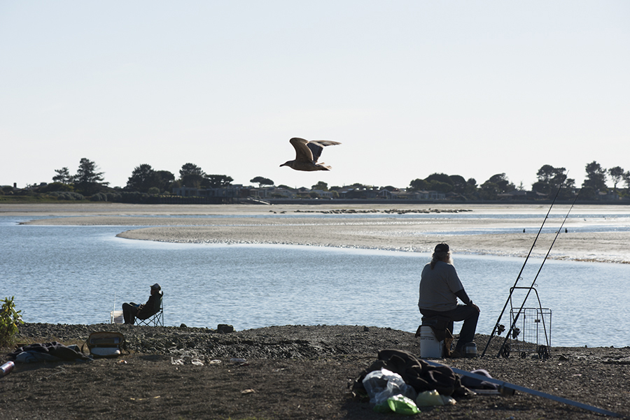
The lagoon is a critical stopover point for many migratory birds, whose tracks are visible in the muddy periphery. On a recent evening, birds meandered about, poking their beaks in the water in search of food or perhaps just enjoying the extra hour of sunlight.
“The scary thing is that Bolinas Lagoon is known for how valuable it is for wintering and migrating shorebirds in particular. A lot of those depend on shallow intertidal mudflats,” said Bill Carmen, the ecologist for the Bolinas Lagoon Restoration Project. But those mudflats could be swallowed up with a rising sea.
In that context, sediment, even man-made, might actually prove advantageous, creating extra habitat for those species.
Scientists say future projects should be directed at ameliorating the effects of flooding and rising sea levels, likely through the restoration of floodplains where possible. Eventually, too, infrastructure must find ways to evade the lagoon’s future footprint. Lifting roads and building bridges and causeways for the water to move under—essentially, a “get out of the way” approach—is inevitable.
“As scientists we’re not going to be sheepish about it. This process will occur whether it’s welcome or not,” said Peter Baye, a coastal ecologist who served on a design review panel of potential restoration projects last summer. He was speaking last Friday at a special meeting of the council, which is comprised of representatives from the community, federal agencies and the county.
But as for commercial boat access to the lagoon—which, in the very short term, could become even shallower—the council says it cannot undertake projects specifically to protect that historic enterprise.
The few fishermen left in the area pull their catch from Bolinas and Bodega Bays, and from deeper seas off the coast, but dock in the lagoon. Sediment has made it difficult to move through the mouth and reach the dock. Occasionally sandy build-up has prevented boats from leaving the dock for up to a week at a time. And although the council does not believe the mouth will close, sediment brought in from the ocean is likely to keep the mouth shallow, even as sea level rises.
Back in the late 1990s and early 2000s, the belief that human activities like logging and stream channelization had triggered the loss of the tidal prism steered restoration plans. The increasingly shallow waters, the logic went, could shut the mouth and threaten subtidal habitat used by fish and crabs as well as intertidal habitat used by birds.
Over a decade ago, the Army Corps of Engineers proposed a multi-million dollar dredging project to address the concern.
But later data proved that the 1906 earthquake dropped the bottom of the lagoon by four feet, making the sediment from the previous century immaterial. And about 80 percent of sediment from the 20th century came from marine beach sand, a natural function of the lagoon filling itself back in after the quake.
That, Mr. Baye said, is the nature of Bolinas Lagoon. “There’s no one natural state. It alternates between two unstable states,” he said.
Still, concerns lingered about the smaller portion of man-made sediment coming in from artificially channelized streams. Those concerns helped inform a list of restoration projects approved by the Board of Supervisors in 2008, known as the Locally Preferred Plan. One significant project, the removal of invasive species from Kent Island, is currently underway.
But climate change and rapid sea level rise are now considered to pose threats by the middle of this century, and invert many previous concerns. The Locally Preferred Plan will not be scrapped, but instead, the urgency surrounding sea level rise—along with feasibility and funding—will direct project priorities. One project to remove tree debris, for instance, has fallen to the bottom of the list, or perhaps off it altogether.
In a few decades, Mr. Baye said, the rising waters could eliminate 40 to 70 percent of the San Francisco Bay region’s intertidal habitat, a zone that provides refuge for shorebirds. The habitat can’t move inland in many areas of the lagoon because Highway 1 and sea walls built to protect private property stall the migration; in those regions, instead of pushing outward, the lagoon will fill like a bathtub.
These habitat encroachments—and the threats they pose to private property—likely won’t be gradual in some cases, but abrupt or occur in spurts triggered by major storms like an El Niño event.
That’s why scientists say extra sediment in many areas could benefit the lagoon.
Mr. Carmen pointed to the artificial channelization of Pine Gulch Creek and the resulting enlarged delta as an example. “Maybe that’s not such a bad thing. That could provide some transitional habitat within the lagoon,” he said.
Future projects will likely focus on restoring and expanding floodplain, which will also provide critical habitat as the lagoon expands.
The next project might be undertaken at the so-called “Y” area of the lagoon, where Highway 1 and Olema-Bolinas Road split in two like a wishbone. The area is prone to flooding, but excising the shortcut road could provide space for the lagoon to expand.
Floodplain restoration around Pine Gulch Creek, which feeds the lagoon after flowing down along Highway 1 and behind Paradise Valley Road before cutting east above the school, could take place in the longer term. That project presents more complications, with potential disagreements over what needs to be done about sediment built up at the delta, which is flanked by private lands.
But Brannon Ketcham, an advisory council member and hydrologist for Point Reyes National Seashore, noted that Pine Gulch Creek is already jumping out in some areas during floods.
Just how homeowners will cope with sea level rise, and affect future projects, remains unclear. Ed Ueber, a council member and former superintendent of Gulf of the Farallones National Marine Sanctuary, said when he worked on the East Coast near Narragansett Bay, a few residents whose homes were constantly flooding simply sold them. The land was then used for floodplain. “They were tired of being inundated,” he said.
Mr. Carmen was a bit more blunt about the prospects of people living close to the shore. “If there is three feet of sea level rise, I don’t see a bright future for the houses that are right on the edge that are having problems now,” he said.
Some projects might not have a fixed time frame. Instead, they could be planned and then implemented when needs or convenient circumstances arise. The restoration of Kent Island, for instance, has taken advantage of the drought, which killed off about 70 percent of invasive iceplant. In the same way, a devastating storm could activate an already-crafted blueprint to lift a road or trigger a plan for land acquisition.
But some at the meeting expressed concerns that the very same storms that provide opportunities for creating so-called accommodation space for sea level rise could also prove problematic if hasty, emergency permits granted to private landowners run counter to the advisory council’s goals.
Mr. Ueber said that private landowners with political power, fearing for their property, often seek emergency repairs for armoring after storms. “A homeowner might say, ‘We gotta riprap this.’ My experience is, it gets riprapped.”
Another attendee at Friday’s meeting said the harm sea walls and other armoring can cause has been known for decades. “I’m just appalled that continued rubber stamping is going on,” she said, wondering if someone needed to educate the California Coastal Commission on the issue.
But Linda Dahl, a council member and the head of the county’s Parks Department, noted that it was easy to oppose those measures—until it’s your own home on the line.
Funding is another issue to consider. Ms. Dahl said that competition was fierce for grants for projects addressing climate change. But she also said she felt a sense of urgency to act. “I want to do something,” she said.
Although Ralph Camiccia, the council’s longtime Bolinas representative, initially expressed skepticism about getting the next project off the ground, the current head of the Gulf of the Farallones National Marine Sanctuary, Maria Brown, disagreed.
“I don’t see minimal projects. I see a very large undertaking,” Ms. Brown said, adding, “I think this will have major international importance…we’re gonna be losing wetlands. We have the opportunity here to restore habitat and to keep habitat healthy.”
“That’s what I like to hear,” Mr. Camiccia responded.
Bolinas resident Jeffrey Labovitz, whose wife’s family was once in the fishing industry, asked what the council would do specifically to protect the tradition for his children and grandchildren and all the people of Bolinas. But he did not get the response he wanted.
“Is this lagoon gonna be a place they can enjoy…with boats and tidal prisms sufficient to maintain these boats?” he asked.
Mr. Ueber said questions about what projects would “turn the lagoon into” were precisely the ones they were trying to avoid.
“We’re gonna keep the lagoon as a healthy vibrant working ecosystem,” he responded. Until they decide on the next project and evaluate its effects, he said he could not answer Mr. Labovitz’s question. “But we’re glad you’re here,” he added.
“Keep asking, ‘Why not this, why that?’”