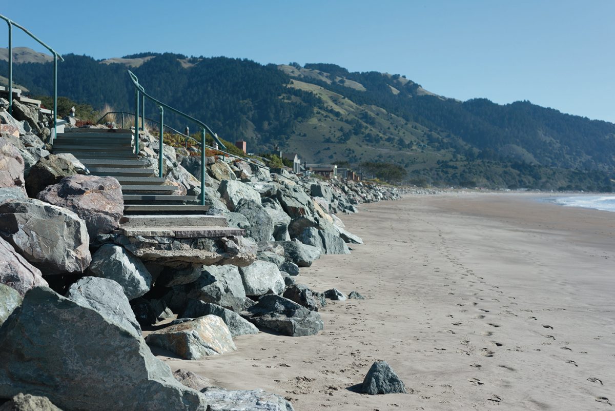
Marin County is scurrying to find solutions for the coastal enclave and popular beachgoer destination of Stinson Beach, which faces inundation by rising seas in the coming decades.
A new study from the Community Development Agency explores the viability of using dunes to prolong the lifetime of neighborhoods and businesses along the 3.5-mile shoreline. The Stinson Beach Nature-Based Adaptation Feasibility Study found that creating and maintaining dunes was a viable option for dispersing intense storm waves and blocking high winter tides.
“We are looking for a climate change adaptation that will allow people to stay in their places longer, protect natural resources, and sustain public beach access,” said Leslie Lacko, a long-range planner with Marin County.
The study considered a near-term sea-level rise of 3.3 feet, the moderate estimated sea-level rise by 2100. Beyond that amount, vulnerabilities begin to stack up and natural infrastructure is less effective.
The Union of Concerned Scientists released a study in 2018 that found that Bay Area coastal communities face significant exposure to chronic inundation by 2045, with flooding of infrastructure predicted 26 times a year. Marin predicts it would take a 10-foot sea-level rise to submerge the entire Stinson Beach sand spit and its multi-million-dollar residential and commercial assets.
Using dunes as buffers against sea-level rise at Stinson Beach comes with significant challenges, including the prevailing wind patterns. For dunes to occur on their own, onshore winds must continually nourish dunes and keep them at an effective height. But at Stinson, prevailing winds run parallel to the shoreline and would blow away dunes over time. Any artificial dunes would have to be maintained on an as-needed basis, especially following major storm events and high tides.
The feasibility study considered several natural infrastructure designs, including cobble berms, foredunes and dune embankments, and weighed them against the varying conditions of the four different reaches of Stinson Beach to determine which would be suitable in each sector.
James Jackson, a consultant with Environmental Science Associates, which conducted the feasibility study in collaboration with the county, suggested how to address the existing conditions of each reach.
On the northernmost end of Stinson, both east and west reaches of Seadrift are suffering the most severe erosion. Both are residential stretches with narrow beach fronts, and Seadrift west has an exposed rock revetment that is the only infrastructure standing between the ocean and homes. Due to the narrowness of the beach at Seadrift west, enhancing the revetment with a short seaside cobble berm and burying it all in sand is the only solution for mitigating sea-level rise.
Seadrift east is slightly wider and the rock revetment is buried by sand and vegetation. An additional dune embankment is suggested on the seaside of the revetment.
The entirety of the Seadrift reach is eroding rapidly and needs immediate attention before the next major storm event, predicted to happen within the next 20 years, the report found.
The Patios reach includes some dunes and homes built directly behind them. To enhance this area, foredunes could be constructed for additional protection. The Calles reach has homes that project out onto the beach and very few existing dunes. The study suggests adding foredunes and a buried cobble berm in front of development.
The National Park Service reach is the widest beach and has the least infrastructure, apart from the lifeguard stand and public restrooms. It is stable and has tall dunes; however, the report suggests adding foredunes there.
While the Calles, Patios and park service reaches are stable for the meantime, the study found that they will experience erosion from future storm events.
Each of the recommendations came with blueprints so that if the county chooses to implement the strategies, the next step would be to secure enough sand. More research would have to be conducted on where the sand would come from, how clean it is, how much it costs and how coarse it must be to be compatible with the beach.
If nature-based options work in the short term, then hard infrastructure such as seawalls and rock revetments are a longer-term solution. Yet hard infrastructure is more difficult to permit and would result in a loss of beaches, easy pedestrian access, wildlife habitat and the associated economic benefits, Ms. Lacko said.
The feasibility study is a part of a larger county effort known as C-SMART, created in 2014, to assess the vulnerabilities of areas along Marin’s coast and develop adaptive responses to sea-level rise.
Jack Liebster is a planning manager with the C.D.A. and a leader of the C-SMART initiative. “Right now, if we did nothing, the beach will begin to get smaller and smaller and eventually disappear before the end of the century,” he said. “Dunes will protect the homes and they will replenish the beach with sediment that will keep it in place.”
Mr. Liebster said the dune study was just a piece of the puzzle. A new Stinson Adaptation and Resilience Collaboration will create a comprehensive adaptation framework with sights on the end of the century and beyond. The effort will pull together research, including the dunes study, so the public can understand the options available for protecting their communities from the encroaching ocean.