atmospheric_river_rating
This week's storm may be rated a three—meaning it brought a beneficial amount of rain but was also hazardous—in northern California, based on a new rating system developed by meteorologists hoping to better describe the "atmospheric rivers" that account for most of the state's rainfall. Above, Highway 1 north of Point Reyes Station. See page 2.   David Briggs

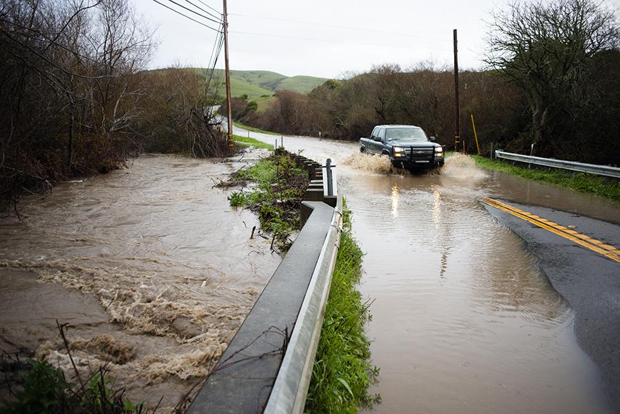
Is California, the state with the greatest year-to-year rainfall variability, prepared for the rain and snow when it comes? A team of hydrometeorological scientists and weather forecasters this month unveiled a new storm rating system in a peer-reviewed study published by the Atmospheric Meteorological Society that they hope will help better describe large precipitation events along the West Coast. The five-point rating system focuses on “atmospheric rivers,” a type of storm system that accounts for up to 50 percent of precipitation in California. Atmospheric rivers begin as warm water storms over the Pacific Ocean, which evaporate into highly concentrated moisture streams and are then funneled west at high velocity by the prevailing winds. Jonathan Rutz, a meteorologist for the National Weather Service who co-authored the report along with leading scientists from the Center for Western Weather and Water Extremes at the Scripps Institution of Oceanography, said the team is analyzing storms retroactively; before putting it into common use, it will hold a colloquium this summer for journalists and other information disseminators. According to the report, atmospheric rivers feed 40 to 90 percent of major floods in West Coast rivers. Forty to 75 percent of droughts on the West Coast end with an atmospheric river event. What distinguishes an atmospheric river from other storm events? Atmospheric rivers are categorized by a unit of measurement called integrated water vapor transport, or IVT, which accounts for both the amount of water vapor and the strength of the wind. An atmospheric river must reach an IVT threshold of 250 units. Remember the storm that released its wrath on the Feather River basin at the start of 2017, causing the Oroville Dam crisis? In the new rating system, that storm is a five. By contrast, the storm in early February that filled reservoirs and caused blackouts in West Marin was a two (although between San Francisco and Los Angeles, the same storm ranked as a three). Though this week’s storm has yet to be categorized, Mr. Rutz said it will likely be a four at the eye toward the south of the state, and a three in the north. It was the wet, cool winter of 2016-2017 that “highlighted the need for greater distinction between the majority of [atmospheric rivers] that are primarily beneficial and the minority of [atmospheric rivers] that are primarily hazardous,” the study states. “The active weather pattern over the western United States during this timeframe led to numerous requests for differentiation between weaker and stronger [atmospheric rivers]—many of these requests came directly from operational staff with the National Weather Service, who must communicate potential impacts to the public.” It takes just a few events to change everything. The top five percent of the wettest days in Northern California—the majority of which are attributed to atmospheric rivers—are responsible for 85 percent of the year-to-year variability for California. Looking forward, Mr. Rutz said that assessing how the probability of larger-scale atmospheric rivers is altered by climate-change projections will become a part of the scientists’ work. At this point, he said, the effect is unclear: “a warmer atmosphere means more water vapor in the atmosphere, which can aid in development of storms and contribute to more moisture-laden [atmospheric rivers].” But, he said, “The catch is that we don’t really know how climate change might affect the atmospheric dynamics that organize the water vapor into [atmospheric rivers]. So it’s possible that even with a wetter atmosphere, their frequency may actually decrease.”