mysteryt_rock_line_tomale_point
The still-mysterious rock line on Tomales Point has baffled historians and hikers for decades.  David Briggs

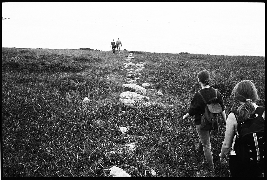
The hundreds of stones lined up off the Tomales Point Trial are so prominent that it’s visible on Google Earth, but high school science teacher Michael Wing missed it for years. When he first read about it, he was surprised. “I thought, ‘That’s crazy.’ I’ve hiked past it a million times and had never seen it. But when I went back, sure enough, there’s a big stone line.” Some people might have let it remain a mystery. But not Mr. Wing.

The line is not interpreted by the Point Reyes National Seashore, and there are differing beliefs regarding its origins. One reference in the ethnographic literature says a stone on a cliff near the ocean represents where the soul departs into the next world, but others have said ranchers probably made the line. After a year-long study, Mr. Wing and two of his students, Katherine Iida and Emily Wearing, concluded that all the evidence they analyzed—the line itself, other stone walls in Marin, the historical record and interviews—indicate that rancher Solomon Pierce probably hired men to lay down the stones intending to construct a wall that was never actually built.

An older map from 1854 the team missed, provided to the Light by the seashore’s archaeologist, could mean that ranchers before Mr. Pierce created the boundary—but it still points to ranching.

Though currently in a draft form, the group plans to send it to the park when it’s finished in the hopes that the seashore will begin interpreting the line. The preserved buildings of the now-defunct 

Pierce Point Ranch are interpreted, they point out, and visitors should understand as much about the line as is known.

In 2009 Mr. Wing, who has a Ph.D. in the earth sciences from the University of California, San Diego, participated in a program that sends teachers to participate in field research expeditions in the colder climes of the world. (He went to Finland.) He realized that a significant amount of fieldwork consists of non-intrusive observations, and lots of data could be gathered, and knowledge gleaned, from surveying.

Sometime after he returned, he read about the stones. But he discovered that little had been written and no firm conclusions drawn as to whether dated from the ranching or prehistoric era.

Ms. Iida and Ms. Wearing, now rising seniors, were intrigued, drawn by the mixture of historical and scientific research. “It combined two of my interests…It’s also really mysterious. We have a theory, but no one really knows why it’s here,” Ms. Iida said.

The line starts at a cliff that overlooks the Pacific Ocean, which on Monday morning was peppered with fishing boats, perhaps looking for salmon or rockfish. That first stone near the cliff is deeply embedded in the earth, most likely the result of soil sliding downslope over the years and slowly burying it. Many of the stones are covered in green lichen and tufts of moss and buried in poison oak, which abounds in the field. The line has a gap at the site of the trail, a former ranch road, where it arcs roughly ten degrees and continues on until it hits a ravine.

The line appears in the historical record in an 1862 survey map of the area; the line on the map shows an oxbow-shaped offshoot and a small square, which the group believes could represent paddocks and a gate.

Between a 1993 report and a 2008 pictoral history, historian Dewey Livingston and seashore archivist Carola DeRooy only wrote that the origins of the line was unknown but appeared to form the ruin of a barrier. (Full disclosure: the Light’s temporary editor, Dewey Livingston, edited this article.)

A graduate student at Sonoma State University, Gavin Gardner, also wrote a paper in 2007 after a one-day survey of the area, during which he was accompanied by three representatives of the Federated Indians of Graton Rancheria; they requested that he name them the “Spirit Jumping-Off Rocks” in his report, which he did.

Mr. Gardner himself could only find one reference in ethnographic literature to the rocks’ possible prehistoric origins, but the reference didn’t specify the line itself. A Coast Miwok man said during an interview in 1991 that “a place of rock about two feet long marks the spot where the dead jump into the ocean.” To Mr. Gardner, it also seemed strange that a rancher would use hundreds of heavy rocks to demarcate the ranches instead of a fence.

But there are no other stone lines that have been traced to the Coast Miwok, according to a board member of the Miwok Archaeological Preserve of Marin that Mr. Wing spoke to. “You don’t go to Europe and find one cathedral, so if this is the Coast Miwok’s equivalent, you would expect to find others,” Mr. Wing said. (The MAPOM board member didn’t believe the Miwok had built it, either.) “It might be an honest misunderstanding…I don’t want to disrespect anyone’s position, but I wanted to focus on what’s on the ground.”

Greg Sarris, the chairman of the Graton Rancheria, said he didn’t know the story. “People call us and they wanted to know about sacred areas, but that’s a total Western notion. Everything is sacred for us…There are several places along the coast where people talked about the spirit going west, but the only one we know for sure is closer to Drakes Bay,” he said.

According to the site surveys, historical research and comparisons with other sites in Marin conducted by Mr. Wing and his two students, a preponderance of the evidence indicates the line was created during the 19th century ranching era.

The two students say they visited the stone line with Mr. Wing about ten times. During their expeditions they found that the line was a uniform half-meter wide. But, they say, there are spots where the line looks haphazardly assembled, with stones scattered near the axis, which they called “satellite” stones, which make sense in the context of a future wall. “If they were eventually going to build it up they would want to bring the stones closer,” Ms. Iida said matter-of-factly.

There are other strange features. There’s a gap in the line they say appears purposeful, as if making way for a barway or paddocks. There are also two large, similar-sized stones near the trail. One that they affectionately named Avebury, a site in Britain similar to Stone Henge, stands up and looks like a tombstone; the other, just beside it, is lying flat.

“So what’s up with that?” Mr. Wing asked rhetorically.

He believes the line would be more precise if it were sacred; as it is, it looks like a rushed job, he said, like someone wanting a border done quickly.

The group visited two stone wall sites in Marin known to have been built in the nineteenth century: one at Indian Hill in Nicasio, the other in Olompali State Park. The one at Indian Hill has an unfinished section that, they say, looks similar to the line at Tomales Point.

Chinese laborers built the wall at Olompali and may have built the one at Indian Hill, too. When Mr. Wing asked nonagenarian Merv McDonald, the last man to ranch at Pierce Point, if he knew anything about the line, he said, “I was always told the Chinese people built that wall.” When asked to clarify if he meant nineteenth century laborers, he answered affirmatively.

The research team, however, is quick to point out that it is not a wall, and they believe it never was. So why would ranchers spend time, energy and money on the stone line if he never completed the job of building into a functional barrier?

Because the team were not aware of the older, 1854 map that also shows a marking indicating a fence or at least a man-made boundary where the line of stones is, the group believed it likely that Mr. Pierce hired men to lay down the stones with the intent of building a wall later that he never actually finished, perhaps because of the invention of barbed wire in the 1870s.

Mr. Pierce, who bought the land from the Shafter law firm in 1858 for $7,000, a major capital investment, was from Vermont, where stone walls were common at the time.

Mr. Wing and his students believed that when Mr. Pierce first bought the land and started investing heavily in his own operations, he was still leasing part of his holdings to to George Laird, who had ranched there for some years. (The historical record is not clear on whether Mr. Laird continued to lease for a few years after the purchase.) So to demarcate the two operations, though it wouldn’t keep cattle from crossing from one area to another, he laid down the stones with the intention of actually building a wall. The strange curve in the line makes sense in that context, since the ravine would also act as a natural border. (If the line kept going straight, it would miss the ravine.)

But the 1854 map puts a serious snag in that theory.

That map, though much cruder than the 1862 map, was made for Andrew Randall, who purchased the land in 1852 from Antonio Osio. Mr. Randall is described by Mr. Livingston in his ranching history of Point Reyes as a “geologist with medical training” who moved to California in 1849. Mr. Randall was originally from Rhode Island, where stone walls also exist, as they do around New England. The map, though rough, clearly shows a line that is used to mark fence lines or at least some kind of boundary.

“It certainly strongly suggests that Solomon Pierce didn’t create this line,” Mr. Wing said after he saw the map.

The 1854 map was brought to the Light’s attention by Paul Engel, the archaeologist for the seashore. He believes it dates from the early ranching era. The stones, he said, are easily available in the area; there are lots of outcroppings. (Mr. Wing believed that, with a few horses or oxen to pull the stones, it could have easily been done in a week or two.) “As an archeologist, I see it as historic, because of the material, the location…I think it’s a property demarcation,” Mr. Engel said, though for what purpose he wasn’t sure.

Interpretation is complicated by differing beliefs about the line, but the park could consider it, he said. “It’s definitely something we would think about doing, but would have to consider the tribe’s sensitivity about that place,” he said. 

That interpretation could still use much of the information the team gathered, such as the similarity to the unfinished wall at Indian Hill and its hastily put together appearance.

“I think it’s important to tell people about it,” Ms. Iida said as she walked back to the trailhead Monday morning, repurposing her meter stick as a walking stick. “And it’s a great feeling to feel you’re contributing to more understanding, and more truth.”

But as to who actually made the line, it’s possible Mr. Randall laid down the stones, though Mr. Wing was unsure why he would. Mr. Laird might have started ranching around that time, though there is no firm date on either when he started running cattle in that particular area. Or maybe in 1854 there was a different kind of fence, perhaps wooden, and when Mr. Pierce came along he planned to install a stone wall instead, and then decided not to, maybe because Mr. Laird left, or maybe because of the invention of barbed wire.

But in the end, who knows?