west_marin_improvement_plan
SAFETY: The Caltrans draft improvement plan includes traffic-control additions intended to promote pedestrian and bicycle safety for West Marin School’s students. The curb at the gas station is pictured may be altered before the plan is implemented.   Courtesy of Abbie Durkee

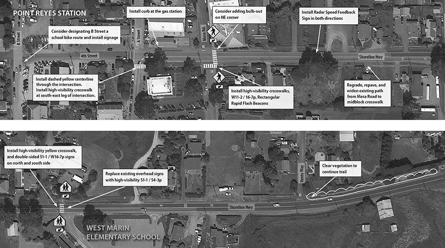
A makeover is in the works to improve pedestrian walkways and add traffic-control measures along Highway 1 from West Marin School to downtown Point Reyes Station, according to a local road-safety advocate who presented a traffic plan drafted by Caltrans and its consultant, Parisi Transportation Consulting. The plan is poised to mark the first step in a broader attempt to tackle the town’s infrastructure gaps as a heavy volume of cars and bicyclists continues to flood downtown.

Spearheaded by Abbie Durkee, a parent who lives near Bear Valley, the plan includes repaving and widening the sidewalk along the hill—known as School Hill—around West Marin School; repainting and brightening existing crosswalks at A Street and Mesa Road, as well as laying down button-activated beacon lights on the one that crosses Mesa; painting a dashed yellow centerline as Highway 1 curves north after Wells Fargo; clearing vegetation along the trail opposite the school; and the possibility of installing a curb at the gas station. 

Caltrans has not yet finalized the plan and there is no timetable for implementation, a spokesperson said. Ms. Durkee indicated that the plan could be incorporated into a future general improvement plan for other areas in town, including the confusing curve at Whale of a Deli.

“We’re looking for a safer route all the way, in sections,” Ms. Durkee said at a meeting sponsored by the Point Reyes Station Village Association at the Dance Palace on Sept. 23. “Right now, the plan is focused on the school zone. I’m asking for input from the community for future plans.”

Ms. Durkee has served as the local volunteer coordinator for Safe Routes to School, a program under the Transportation Authority of Marin that focuses on improving infrastructure around schools, educating students on pedestrian safety and making school transportation “greener.” In March, Ms. Durkee surveyed the school-zone area with a task force organized to address safety concerns around West Marin School and came up with recommendations for infrastructure improvements. That task force included Ms. Durkee, Safe Routes to School Program Director Wendi Kallins, West Marin School Principal Matt Nagle, teacher Chris Eckert, two civil engineers and representatives from Caltrans and the Marin County Department of Public Works. In the following months, Ms. Durkee collaborated with the engineers via email to help formulate the draft improvement plan, and received input from the task force as well as the director of the Tomales Bay Youth Center, Madeline Hope.

Though Ms. Durkee said the draft plan has been approved by Caltrans, she noted that certain changes depend on jurisdictional issues north of the school, while some plan details could change with additional community input.

Some people have taken issue with the curb proposed between the gas station and Highway 1, citing the potential to create an unsafe and inconvenient impediment.

“To me, that seems like that would be prohibitive of how cars get into and out of certain spots,” said Nick Whitney, of Inverness, an arborist who foresees an access problem for his truck’s crane

The school-zone plan is also meant to redirect students on bicycles going to and from school, proposing to direct cyclists down School Hill onto B Street. But some worried about residents who, keen to avoid Main Street, often take the back road—and often at high speeds. “To me, B Street is just as dangerous as Main Street,” said Ken Otter, president of the village association. 

Speaking at that meeting, substation commander Lieutenant Doug Pittman of the Marin County Sheriff’s Office noted that about 90 percent of people cited for traffic violations, in his experience, have been local drivers. He hinted that officers may soon start cracking down on speedy drivers accelerating down School Hill and through B Street.

“I don’t think anyone has a perfect answer,” Lt. Pittman said. “But these are all stepping stones. I’m going to need everyone in the community to spread the word about what we want to have happen here.”

At a second community meeting held at West Marin School last Thursday, Marin County Supervisor Steve Kinsey echoed Lt. Pittman’s call for local community members to speak with a unified voice to better sway Caltrans and county reps. “It’s especially important for the community to decide how important each issue is,” he said.

That meeting—the third in an ongoing series of invitation-only gatherings for business leaders—was attended by Bijan Sartipi, Caltran’s district director for the Bay Area. His office manages around 7,000 miles of state highway, including the Green Bridge.

“With the vast infrastructure that we have in the Bay Area, our resources have not been able to keep up with the needs,” said Mr. Sartipi, who serves with Mr. Kinsey on the region’s Metropolitan Transportation Commission. 

To prepare for the rainy season and an expected El Niño event, Mr. Sartipi added, Caltrans will be providing routine maintenance and upkeep for small drainage projects around town, such as for the flood-prone sidewalk outside the Palace Market.

Meanwhile, Ms. Durkee hopes that any larger Caltrans plan for Point Reyes Station addresses pedestrian and bicycle safety all the way to Inverness, where many students live and bicycle lanes are more or less nonexistent. On school days, Ms. Durkee and her son, Dustin, have to cross the road three times to get from her home in Inverness Park to the Green Bridge. 

“We live among the trees and we have very few roads,” Ms. Durkee said. “We all can feel the congestion.”